|
| SuperCOSMOS |
| H-alpha Survey (SHS) |
|
|
|
|
|
|
|
|
|
|
|
|
|
|
|
|
|
| |
 | |
| IFA ROE |
Step-by-Step Guide to extracting image data from the SHS
This page describes the typical steps a user might go through when extracting data using the image extraction form Get an Image under the SHS web interface to the AAO/UKST H-alpha survey of the Southern Galactic Plane. It is aimed at the first-time user and goes on to describe how the data can be displayed and interrogated using the GAIA software package.The form allows the user to extract a region up to 900 sq.arcmin in total area from SuperCOSMOS scans of the H-alpha survey. If the requested region of the survey is on-line a pixel image (FITS format) with an embedded object catalogue (FITS table) is returned.
- Step 1 - assuming you already know the equatorial co-ordinates
in RA (hours minutes seconds) and Dec (degrees, minutes, seconds) of your object (for either
equinox B1950 or J2000) or you know the Galactic l,b co-ordinates (in decimal degrees)
you can proceed directly to the form located at
http://www-wfau.roe.ac.uk/sss/halpha/pixel.html.
Packages such as
coco
allow you to convert between various equinoxes and coordinate systems (galactic, ecliptic,
equatorial etc).
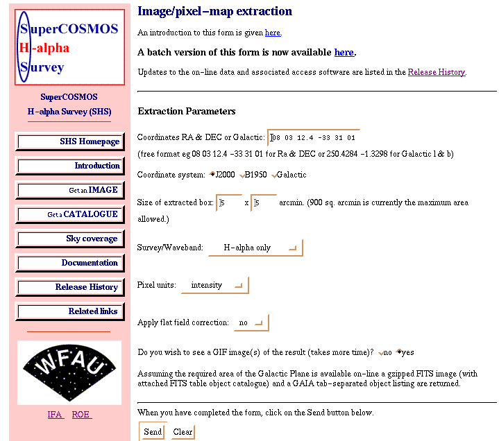
- Step 2 - fill in the on-line form using the boxes and buttons
provided.
Coordinates: The form should ignore all input characters apart from numbers and + or - and replaces them with blanks. i.e if you wanted to enter the RA and Dec as 08:09:32.6 -36:04:55 the form will work but it is really expecting 08 09 32.6 -36 04 55 so to avoid mis-interpretation try and stick to this format. For the l,b co-ordinate option you should always enter values in decimal degrees (e.g. 253.2914 -1.6125)
Equinox: Select J2000 (default) or B1950 from the menu if using RA/Dec
X-Y region size: Enter values for the size of the rectangular region to be extracted in X and Y in arcminutes; e.g. 0.1 < size < 30 arcmin for a square region. If a rectangular region is required this must not exceed a total area of 900.sq.arcmin.
Galactic Plane survey waveband: Select either the H-alpha, SR or both button for the pixel image(s) you wish to obtain.
The on-line availability of the Galactic Plane H-alpha survey fields can be found under Galactic Plane coverage.Pixel Units: There are three choices available: Density (default), Intensity and Transmission. Again this choice is a new feature introduced for the SHS data and is not available for the standard SSS which uses pixel units in density space converted to an integer range from 0-37767.
Apply Flat-Field correction: This option, unique to the H-alpha survey data, is offered due to the low level (few percent) transmission variations that occur across the surface of the narrow-band inteference filter used to obtain the H-alpha survey images. These can, in principle, be moderated by use of a Flat-field pretty much in the same way that a normal CCD image is corrected. Images of the H-alpha survey Flat-Field and further details about this option are givenhere so the user can make an informed choice as to whether this option should be selected. Note however that the IAM object data produced from the SuperCOSMOS scans has been derived in the standard way without the application of a Flat-Field.
GIF: If you wish a GIF image of the area(s) requested click the circle next to "yes" to over-ride the deafult "no". Producing the GIF file(s) takes a bit more time. Note that the GIF images are intended for visualisation purposes only and are not meant for serious scientific use. Also note that a FITS file is
always returned. Once downloaded, FITS files can be readily converted to GIFs, JPEGs etc, e.g. using "xv".)Once the form is filled in click on "send". An example of a filled-in form as a screen capture is given here.
- Step 3 - if the requested part of the plane is up on disk you should
see a results page something like this. The GIF image
(if requested) is displayed at 200x200 pixels, click on the image to view it at its
full resolution.
As well as links to the gzipped FITS file and GAIA listing the form also returns a link to a data guide.
If the scanned data has not yet been put on-line or you have requested a region outwith the survey area then the form should return an "error" message. Similarly if the form cannot handle the data you have entered (eg if the size is larger than 30 arcmin) then you will be informed. If you think you have entered sensible parameters and the chart of scanned data (located here) indicate the survey field has been put on-line then please email mar@roe.ac.uk with the search parameters used and the messages returned.
- Step 4 - To save the gzipped FITS image to your local disk
space click (in Netscape use shift + mouse button 1, in Internet
Explorer use the right mouse button + `Save target as') on the `FITS.gz'
button. Some browsers are configured so that the FITS file is
automatically
uncompressed on download. If the file is saved in the compressed format
then use the Unix command gunzip to uncompress it. (PC/Windows users can use
packages such as Winzip to uncompress files)
If you wish to save the GAIA listing of the object catalogue to disk then `click' on the `Tab' button as described in the previous paragraph.
Home | Intro | Get an Image | Get a Catalogue
Coverage | Documentation | History | Links
WFAU, Institute for Astronomy,
Royal Observatory, Blackford Hill
Edinburgh, EH9 3HJ, UK
Tel +44 131 668 8356 (office)
or +44 131 668 8100 (switchboard)
M.Read@roe.ac.uk 21-Jan-2002
![]()